
(1928). Looking northwest to the Low Islands, Queensland, 1928.
The English explorer Captain James Cook recorded the existence of these islands in 1770 during his voyage of discovery to Australia, describing “a small low island”.
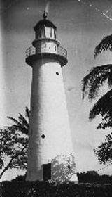
Officially named Low Isles in 1819, a lighthouse was built on the coral cay in 1878. It was the tenth commissioned by the Queensland Government to help create the longest shipping lane in the world and has been an important navigational aid to shipping along the inner Great Barrier Reef.
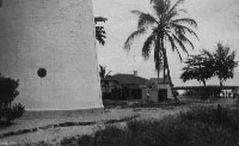
It is listed on the Register of the National Estate as a significant part of Australia’s cultural heritage and there was a continuous presence of lighthouse keepers on Low isles up until 1993 when the lighthouse became automated.
Scientific values of Low Isles derive from its diversity of natural features and with the 1928-29 Great Barrier Reef Expedition it became the site of the first detailed scientific study of a coral reef anywhere in the world.
Led by Dr C.M. Yonge the expedition aimed to study the life processes of coral and formation of the reef with more than 20 renowned natural scientists involved. Results from the expedition were published by the British Natural History Museum in six large volumes.
It is one of the few coral reefs in the world for which a long series of data exists and presents an unusual and valuable opportunity for continuing long term studies and comparison with modern research.
Cultural values have long existed with the Low Isles (Wungkun) regarded as an important Indigenous site for both the KuKu Yalanji and Yirraganydji Indigenous clans, where the sea country of both groups overlap. Over time, Low Isles has been perceived as a peace island, a place to settle disagreements.

Historical timeline
This history has been compiled by the Port Douglas Historical Society
On Queensland's Great Barrier Reef, the Low Isles (Islets) are two small coral cays located 13 kilometres from Port Douglas. They are situated on the western edge of the main shipping channel. One is known as Low Isles and the other as Woody Island. Woody is a protected area.
Aboriginal people know these islands as Wungkun. It is an important Indigenous cultural site for both the KuKu Yalanji and Yirraganydji Aboriginal tribes. The Sea Country of both groups overlaps at Low Isles.
June 10, 1770
Captain James Cook, sailing past Low Isles in HMS Endeavour, made a note in his log describing a "small low island".
1819
Captain Phillip Parker King, on the cutter Mermaid, officially named Low Isles and Cooktown, previously Cook’s Town.
1842
The first to study the Reef was conducted by Professor Beete Jukes who came on the survey onboard vessel HMS Fly.
1860s/70s
A beche-de-mer station was established.
November 1878
The light, on the flat low-lying western island, was exhibited for the first time from the new lighthouse, the first keeper being Captain Daniel Owen, previous master of the S.S.Corea. The original 1878 lens for the light is on display in the Court House Museum.
March 19, 1907
William Hannah, aged 42, his daughter Doris Irene Margaret Wallace Hannah (aged 14 years), and son William Thompson Escar Hannah (aged ten years), went missing in a dinghy. A Magisterial enquiry held in Brisbane failed to find any explanation for their disappearance.
July 1907
Hugh Nibloe arrived from Glasgow to be the light house keeper. (see DSHS Bulletin no.17) Woody Island then was called Low Woody. The head keeper was Mr Simpson.
October 1911
Three bodies were found. At first they were thought to be of three missing young men from the Valda who went missing sailing to Green Island, but two of the bodies were children, thought to be the Hannah family..
Cyclone Leonta – some coastal boats were lost with all lives
February 7, 1912
The bodies of the Hannahs were interred in McLeod St Cemetery in Cairns in an unmarked grave.
July 16, 1928
The world’s first detailed scientific study of coral reef took place on Low Isles. The European expedition party, led by Dr C. M. Yonge, aimed to study the life processes of coral and of the formation and maintenance of reef.
July 28, 1929
The expedition left Low Isles.
March 12, 1934
A cyclone destroyed outbuildings on the island. 79 lives were lost at sea in the area north to Cooktown.
Early 1960s
The original cottages were built in a radial arc around the tower. The same arrangement was used when these cottages were replaced in the early 1960s.
1963
The light was upgraded to electric operation. A new fibro boat house was built.
1979
The first daily cruise to Low Isles began with the Martin Cash owned by Jim and Jo Wallace.
1981
The Great Barrier Reef, one of Australia's first World Heritage Areas, was inscribed on the World Heritage List in recognition of its outstanding natural universal values.
1992
The Australian Maritime Safety Authority announced it was removing the lighthouse keepers from Low Isles and automating the lighthouse. The title would be transferred to the Marine Parks.
LIPS was formed, the Low Isles Protection Society. A Queensland Parks and Wildlife (QPWS) Ranger would be based on the Isles, and an Indigenous ranger at Port Douglas.
1993
The solar conversion and installation of a 16 nautical miles self-contained beacon was made, when the station became de-manned. The lighthouse is now controlled by Queensland Parks and Wildlife Service.
1994
The last lighthouse keeper left.
LIPS initiated a volunteer marine ranger position.
1996
The first trainee rangers graduated from a pilot Volunteer Marine Ranger Training program, initiated to involve the community volunteers in the management of marine parks. Volunteer marine rangers relieve the permanent Low Isles ranger for approximately 100 days per year.
March 6, 2000
The Low Isles Heritage Walk was officially opened.
Several commercial tour boats visit Low Isles daily. Woody Island is a protected wildlife sanctuary
Compiled by Pam Willis Burden in March 2006. A more detailed timeline has been published as a Bulletin, and is available from the Douglas Shire Historical Society.

Low Isles (1878)
The usual anchorage is in 10 metres, sand and mud, with the lighthouse in transit with Mt Harris bearing 1950. The Need of the mangroves bearing 125° and the channel beacon bearing 171 °. This is 3 cables from the island and the coral bank bearing 125°. These radar ranges will vary slightly according to the state of the tide and reef exposed.
Distance from the channel beacon is 3 cables. At night run in with the light bearing 195° and anchor 3.25 cables off.
The landing is on the eastern side of the sand islet and is approached through a narrow channel about half way between the two islands. Course from the anchorage is south leaving the channel beacon wide to starboard. Keep a good lookout for coral heads of which there are several east of the coral patch, marked by the beacon.
Alter course to starboard when SE of the beacon and run in for the beach. Landing can be affected at all states of the tide by either larc or boat.
— AN371 24.04.2000 (Not updated) Note: 3.1997. National Parks Ranger, Jeff Ilif
